
Ficheiro:EFS highres STS091 STS091-731-32.JPG

Imagem numa resolução maior (4 078 × 4 078 píxeis, tamanho: 15,84 MB, tipo MIME: image/jpeg)
|
|
Esta imagem provém do Wikimedia Commons, um acervo de conteúdo livre da Wikimedia Foundation que pode ser utilizado por outros projetos.
|
Descrição do ficheiro
| Descrição |
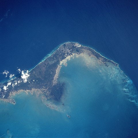
English: STS091-731-032 Grand Bahama Island, Freeport and Lucaya, Bahamas June 1998
The small cities of Freeport and Lucaya, on the southwest portion of Grand Bahama Island (slightly above the center of the view), can be seen in this southwest-looking view. Freeport and Lucaya are the Bahamas second largest metropolitan area. Nearly 50 years ago, neither city even existed. The Freeport and Lucaya region is a free trade zone area. Besides numerous tourist resorts and recreational areas, Freeport and Lucaya’s other activities include oil refining, cement production, distilling of liquor, and making of pharmaceutical products. As with the other islands of the Bahamas, Grand Bahama is composed largely of calcareous materials derived from marine organisms. A karst landscape covers many of the higher elevations on the island. Grand Bahama Island is 96 miles (154 km) long and 17 miles (27 km) at its widest point. The darker blue, deep waters of the Atlantic Ocean are visible in the upper portion of the view. The lighter blue, shallow waters covering the Bahama Shelf are discernible in the bottom portion of the view. Images: All Available Images Low-Resolution 277k Mission: STS091 Roll - Frame: 731 - 32 Geographical Name: BAHAMAS Features: FREEPORT, GRAND BAHAMA I. Center Lat x Lon: 26.5N x 78.5W Film Exposure: N N=Normal exposure, U=Under exposed, O=Over exposed, F=out of Focus Percentage of Cloud Cover-CLDP: 5 Camera: HB Camera Tilt: 16 LO=Low Oblique, HO=High Oblique, NV=Near Vertical Camera Focal Length: 250 Nadir to Photo Center Direction: NW The direction from the nadir to the center point, N=North, S=South, E=East, W=West Stereo?: Y Y=Yes there is an adjacent picture of the same area, N=No there isn't Orbit Number: 78 Date: 19980607 YYYYMMDD Time: 195254 GMT HHMMSS Nadir Lat: 25.8N Latitude of suborbital point of spacecraft Nadir Lon: 77.9W Longitude of suborbital point of spacecraft Sun Azimuth: 274 Clockwise angle in degrees from north to the sun measured at the nadir point Space Craft Altitude: 198 nautical miles Sun Elevation: 53 Angle in degrees between the horizon and the sun, measured at the nadir point Land Views: ISLAND, COAST Water Views: OCEAN Atmosphere Views: Man Made Views: URBAN AREA, AIRPORT City Views: FREEPORT |
| Data | |
| Origem |
http://eol.jsc.nasa.gov/sseop/EFS/photoinfo.pl?PHOTO=STS091-731-32 http://eol.jsc.nasa.gov/scripts/sseop/LargeImageAccess.pl?directory=EFS/highres/STS091&filename=STS091-731-32.JPG&filesize=16606733 |
| Autor | Image Science and Analysis Laboratory, NASA-Johnson Space Center |
Este(a) imagem ou vídeo foi catalogado(a) por um dos centros dos Estados Unidos da América para a Administração Nacional da Aeronáutica e do Espaço (NASA), sobre o código ID: STS091-731-32. Esta marcação não indica o estado dos direitos de autor da obra aqui mostrada. Continua a ser necessária uma marcação normal de direitos de autor. Veja Commons:Licenciamento para mais informações. Outras línguas:
|
Licenciamento
| Este ficheiro está no domínio público nos Estados Unidos porque foi criado exclusivamente pela NASA. As orientações sobre o direito de autor da NASA são que «as obras da NASA não têm os direitos de autor protegidos salvo indicação em contrário». Veja Template:PD-USGov, as orientações sobre o direito de autor da NASA ou as normas de uso de imagens do Laboratório de Propulsão a Jato (Jet Propulsion Lab, JPL). | ||
 |
Avisos:
|
Histórico do ficheiro
Clique uma data e hora para ver o ficheiro tal como ele se encontrava nessa altura.
| Data e hora | Miniatura | Dimensões | Utilizador | Comentário | |
|---|---|---|---|---|---|
| atual | 08h26min de 14 de abril de 2011 | | 4 078 × 4 078 (15,84 MB) | Andkore | {{Information |Description ={{en|1=STS091-731-032 Grand Bahama Island, Freeport and Lucaya, Bahamas June 1998 The small cities of Freeport and Lucaya, on the southwest portion of Grand Bahama Island (slightly above the center of the view), can be seen |
Utilização local do ficheiro
A seguinte página usa este ficheiro:
Utilização global do ficheiro
As seguintes wikis usam este ficheiro:
- el.wikipedia.org
- en.wikipedia.org
- es.wikipedia.org
- eu.wikipedia.org
- fa.wikipedia.org
- fo.wikipedia.org
- fr.wikipedia.org
- ja.wikipedia.org
- ka.wikipedia.org
- nl.wikipedia.org
- sr.wikipedia.org
- tr.wikipedia.org
- zh.wikipedia.org