
Ficheiro:Gwash map02.jpg
Imagem numa resolução maior (3 227 × 2 390 píxeis, tamanho: 1,77 MB, tipo MIME: image/jpeg)
|
|
Esta imagem provém do Wikimedia Commons, um acervo de conteúdo livre da Wikimedia Foundation que pode ser utilizado por outros projetos.
|
Descrição do ficheiro
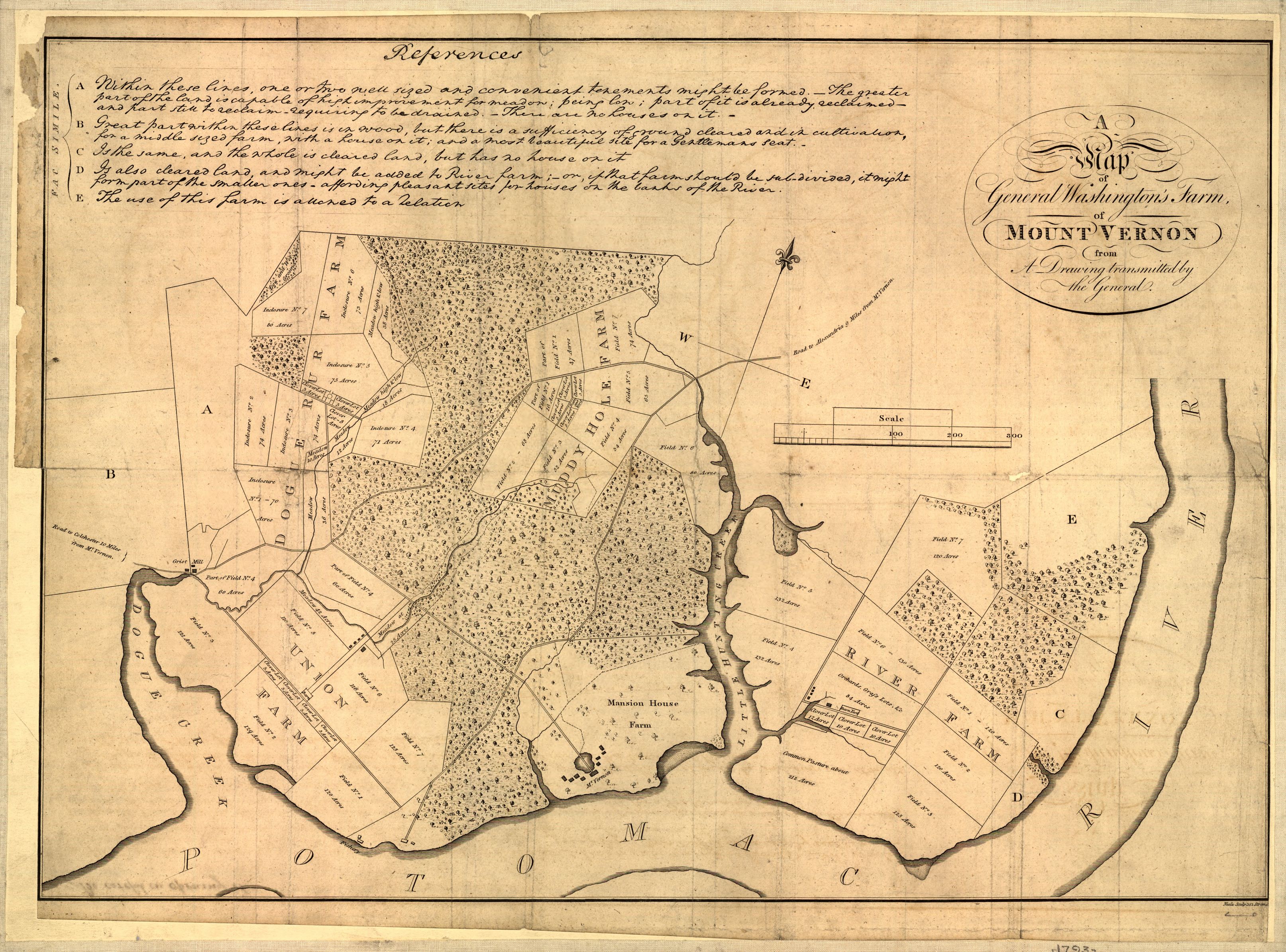
Map of Mount Vernon, residence of George Washington made by himself.
A map of General Washington's farm of Mount Vernon from a drawing transmitted by the General.
Uploaded from http://hdl.loc.gov/loc.gmd/g3882m.ct000367.
Notes from Library of Congress page:
CREATED/PUBLISHED [S.l., 1801]
NOTES Removed from: Letters from His Excellency George Washington, to Arthur Young, [etc.]. London, 1801. Opp. p. (E312.75.A27 Rare Book Rm.)
Scale 1:6,336.
SUBJECTS Mount Vernon (Va. : Estate)--Maps--Early works to 1800. United States--Virginia--Mount Vernon (Estate)
MEDIUM 1 map ; 37 x 52 cm.
CALL NUMBER G3882.M7 1793 .W34 1801 TIL Vault
REPOSITORY Library of Congress Geography and Map Division Washington, D.C. 20540-4650
DIGITAL ID g3882m ct000367

|
Este mapa está disponível na Divisão de Geografia e Cartografia da Biblioteca do Congresso dos Estados Unidos com o número de identificação digital g3882m.ct000367.
Esta marcação não indica o estado dos direitos de autor da obra aqui mostrada. Continua a ser necessária uma marcação normal de direitos de autor. Veja Commons:Licenciamento para mais informações.
|
Licenciamento
|
Esta obra está no domínio público no seu país de origem e noutros países e áreas onde o período de proteção dos direitos de autor é igual ou inferior à vida do autor mais 70 anos.
| |
| Este ficheiro foi considerado livre de restrições conhecidas devidas a direitos de autor, incluindo todos os direitos conexos. | |
Histórico do ficheiro
Clique uma data e hora para ver o ficheiro tal como ele se encontrava nessa altura.
| Data e hora | Miniatura | Dimensões | Utilizador | Comentário | |
|---|---|---|---|---|---|
| atual | 02h17min de 1 de outubro de 2006 | | 3 227 × 2 390 (1,77 MB) | Clindberg | Reupload from http://hdl.loc.gov/loc.gmd/g3882m.ct000367 with higher resolution; change license (not USGov but is PD-old) |
| 13h01min de 6 de junho de 2005 |  | 804 × 600 (138 kB) | Herrick~commonswiki | Map of Mount Vernon, residence of George Washington made by himself. A map of General Washington's farm of Mount Vernon from a drawing transmitted by the General. {{PD-USGov}} Washington, George, 1732-1799. CREATED/PUBLISHED [S.l., 1801] NOTES |
Utilização local do ficheiro
A seguinte página usa este ficheiro:
Utilização global do ficheiro
As seguintes wikis usam este ficheiro:
- de.wikipedia.org
- en.wikipedia.org
- fr.wikipedia.org
- it.wikipedia.org
- ja.wikipedia.org
- ko.wikipedia.org
- nl.wikipedia.org