
Ficheiro:Map of the Territory of the Iceni.svg

Dimensões desta antevisão em PNG do ficheiro SVG: 424 × 600 píxeis Outras resoluções: 170 × 240 píxeis | 339 × 480 píxeis | 543 × 768 píxeis | 724 × 1 024 píxeis | 1 448 × 2 048 píxeis | 744 × 1 052 píxeis.
Imagem numa resolução maior (ficheiro SVG, de 744 × 1 052 píxeis, tamanho: 151 kB)
|
|
Esta imagem provém do Wikimedia Commons, um acervo de conteúdo livre da Wikimedia Foundation que pode ser utilizado por outros projetos.
|
| Descrição |
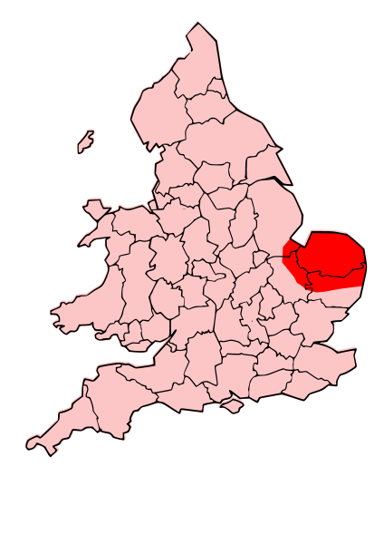
English: A map showing the territory of the Iceni tribe overlayed in red in the context of the modern county boundaries of England and wales |
| Data | (UTC) |
| Origem | |
| Autor |
|
.svg)
.png)
| Esta é uma imagem retocada, o que significa que a versão original foi alterada digitalmente. Modificações: Revised to show extent of Iceni Territory. O original pode ser visto aqui: Map of the Territory of the Dobunni.svg:
|
A utilização deste ficheiro é regulada nos termos da licença Creative Commons - Atribuição-CompartilhaIgual 3.0 Não Adaptada.
- Pode:
- partilhar – copiar, distribuir e transmitir a obra
- recombinar – criar obras derivadas
- De acordo com as seguintes condições:
- atribuição – Tem de fazer a devida atribuição da autoria, fornecer uma hiperligação para a licença e indicar se foram feitas alterações. Pode fazê-lo de qualquer forma razoável, mas não de forma a sugerir que o licenciador o apoia ou subscreve o seu uso da obra.
- partilha nos termos da mesma licença – Se remisturar, transformar ou ampliar o conteúdo, tem de distribuir as suas contribuições com a mesma licença ou uma licença compatível com a original.
Registo de carregamento original
This image is a derivative work of the following images:
- File:England_Celtic_tribes_-_South.png licensed with Cc-by-sa-3.0-migrated, GFDL
- 2007-11-16T12:21:48Z File Upload Bot (Magnus Manske) 550x297 (105767 Bytes) {{BotMoveToCommons|en.wikipedia}} {{Information |Description={{en|Image depicting the Celts of South England, pre-[[:en:Roman Britain]] times. I created this myself, under the guidence (to find location of them) of [http://w
- File:Map_of_the_Territory_of_the_Dobunni.svg licensed with Cc-by-sa-3.0, GFDL
- 2009-10-13T19:47:34Z Jpb1301 744x1052 (151192 Bytes) {{Information |Description={{en|1=A map showing the territory of the Dobunni tribe overlayed in red in the context of the modern county boundaries of England and wales}} |Source=*[[:File:Map_of_the_Territory_of_the_Dobunni.sv
- 2009-10-13T17:38:36Z Jpb1301 744x1052 (151194 Bytes) {{Information |Description={{en|1=A map showing the territory of the Dobunni tribe overlayed in red in the context of the modern county boundaries of England and wales}} |Source=*[[:File:Map_of_the_Territory_of_the_Cornovii_(
Carregada com derivativeFX
Histórico do ficheiro
Clique uma data e hora para ver o ficheiro tal como ele se encontrava nessa altura.
| Data e hora | Miniatura | Dimensões | Utilizador | Comentário | |
|---|---|---|---|---|---|
| atual | 19h30min de 24 de outubro de 2009 | | 744 × 1 052 (151 kB) | Jpb1301 | {{Information |Description={{en|1=A map showing the territory of the Iceni tribe overlayed in red in the context of the modern county boundaries of England and wales}} |Source=*File:England_Celtic_tribes_-_South.png *[[:File:Map_of_the_Territory_of_ |
Utilização local do ficheiro
A seguinte página usa este ficheiro:
Utilização global do ficheiro
As seguintes wikis usam este ficheiro:
- ar.wikipedia.org
- bg.wikipedia.org
- br.wikipedia.org
- ca.wikipedia.org
- da.wikipedia.org
- en.wikipedia.org
- es.wikipedia.org
- fa.wikipedia.org
- fi.wikipedia.org
- he.wikipedia.org
- hr.wikipedia.org
- hy.wikipedia.org
- id.wikipedia.org
- it.wikipedia.org
- ja.wikipedia.org
- la.wikipedia.org
- nl.wikipedia.org
- no.wikipedia.org
- pl.wikipedia.org
- ro.wikipedia.org
- ru.wikipedia.org
- si.wikipedia.org
- sv.wikipedia.org
- uk.wikipedia.org
- ur.wikipedia.org