
Ficheiro:Map of the southern Balkans, 1410.svg

Dimensões desta antevisão em PNG do ficheiro SVG: 679 × 600 píxeis Outras resoluções: 272 × 240 píxeis | 543 × 480 píxeis | 869 × 768 píxeis | 1 159 × 1 024 píxeis | 2 318 × 2 048 píxeis | 2 217 × 1 959 píxeis.
Imagem numa resolução maior (ficheiro SVG, de 2 217 × 1 959 píxeis, tamanho: 2,56 MB)
|
|
Esta imagem provém do Wikimedia Commons, um acervo de conteúdo livre da Wikimedia Foundation que pode ser utilizado por outros projetos.
|
Descrição do ficheiro
| Descrição |
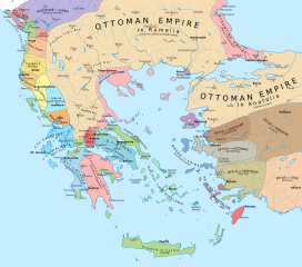
English: Political map of the southern Balkans and western Anatolia in 1410. Disclaimer: The borders shown are often uncertain and conjectural; an effort has been made to be as accurate as possible and follow the relevant scholarship, but errors or omissions may still be present. Any help in correcting and/or improving this work would be greatly appreciated. |
| Data | |
| Origem |
Obra própria, usando:
|
| Autor | Constantine Plakidas |
Licenciamento
Eu, titular dos direitos de autor desta obra, publico-a com a seguinte licença:
A utilização deste ficheiro é regulada nos termos da licença Creative Commons Atribuição-CompartilhaIgual 4.0 Internacional.
- Pode:
- partilhar – copiar, distribuir e transmitir a obra
- recombinar – criar obras derivadas
- De acordo com as seguintes condições:
- atribuição – Tem de fazer a devida atribuição da autoria, fornecer uma hiperligação para a licença e indicar se foram feitas alterações. Pode fazê-lo de qualquer forma razoável, mas não de forma a sugerir que o licenciador o apoia ou subscreve o seu uso da obra.
- partilha nos termos da mesma licença – Se remisturar, transformar ou ampliar o conteúdo, tem de distribuir as suas contribuições com a mesma licença ou uma licença compatível com a original.
Histórico do ficheiro
Clique uma data e hora para ver o ficheiro tal como ele se encontrava nessa altura.
| Data e hora | Miniatura | Dimensões | Utilizador | Comentário | |
|---|---|---|---|---|---|
| atual | 10h16min de 2 de abril de 2023 | | 2 217 × 1 959 (2,56 MB) | Cplakidas | cleanup of whitespaces, white background instead of transparent |
| 16h24min de 19 de novembro de 2019 |  | 2 217 × 1 959 (2,58 MB) | Cplakidas | forgot some things.. | |
| 16h17min de 19 de novembro de 2019 |  | 2 217 × 1 959 (1,29 MB) | Cplakidas | modified Byzantine borders in Bithynia to cover northern part of the Gulf of Nicomedia/Izmit (cf. en:Treaty of Gallipoli) | |
| 14h46min de 23 de março de 2018 |  | 2 217 × 1 959 (3,42 MB) | Cplakidas | city names to paths | |
| 13h46min de 23 de março de 2018 |  | 2 217 × 1 959 (2,39 MB) | Cplakidas | User created page with UploadWizard |
Utilização local do ficheiro
As seguintes 2 páginas usam este ficheiro:
Utilização global do ficheiro
As seguintes wikis usam este ficheiro:
- ar.wikipedia.org
- azb.wikipedia.org
- bg.wikipedia.org
- bs.wikipedia.org
- de.wikipedia.org
- en.wikipedia.org
- fr.wikipedia.org
- he.wikipedia.org
- hu.wikipedia.org
- hy.wikipedia.org
- it.wikipedia.org
- ka.wikipedia.org
- mk.wikipedia.org
- pl.wikipedia.org
- ru.wikipedia.org
- sl.wikipedia.org
- tr.wikipedia.org
Ver mais utilizações globais deste ficheiro.