
Ficheiro:Paraná River Floodplain, Northern Argentina.jpg

Imagem numa resolução maior (4 288 × 2 850 píxeis, tamanho: 3,8 MB, tipo MIME: image/jpeg)
|
|
Esta imagem provém do Wikimedia Commons, um acervo de conteúdo livre da Wikimedia Foundation que pode ser utilizado por outros projetos.
|
Descrição do ficheiro
| Descrição |
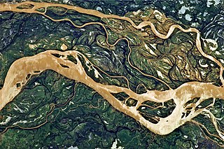
English: This astronaut photograph shows a 29-kilometre stretch of the Paraná, downstream of the small city of Goya, Argentina (just off the top left of the image).
The Paraná River ranges up to 3 kilometres wide along the reach illustrated in this image. The main channel is deep enough to allow smaller ocean-going ships to pass north to the capital city of Asunción, Paraguay, fully 1,200 kilometres inland and well out of the image. The river’s dark brown shading indicates a heavy load of muddy sediment; smaller side channels also carry this mud. Numerous lakes are typical on active floodplains, and appear here as irregular bodies of water. Some appear brown, indicating that they probably have been refilled during recent rises and floods of the active channels. The Paraná floodplain occupies the entire image; it is so wide—18 kilometres in this view—that its banks are not visible. Numerous curved, meandering channels are the most prominent characteristic of the floodplain, indicating prior positions of the river and its channels. As riverbeds move laterally by natural processes, they leave remnants of their channels, which appear as lakes and finally fill with mud. This is an excellent image for illustrating these meander forms. From a geological standpoint, it is interesting that almost all of the old channels are similar in curvature to today’s side channels. However, almost none of them seem to show prior positions of the main, wide Paraná channel. |
| Data | |
| Origem | NASA Earth Observatory |
| Autor | ISS Expedition 27 crew |
| Localização da câmara | | Esta e outras imagens nas suas localizações em: OpenStreetMap |
|---|
Este(a) imagem ou vídeo foi catalogado(a) por Centro Espacial Johnson dos Estados Unidos da América para a Administração Nacional da Aeronáutica e do Espaço (NASA), sobre o código ID: ISS027-E-11058. Esta marcação não indica o estado dos direitos de autor da obra aqui mostrada. Continua a ser necessária uma marcação normal de direitos de autor. Veja Commons:Licenciamento para mais informações. Outras línguas:
|
Image acquired with a Nikon D2Xs digital camera using a 400 mm lens, and is provided by the ISS Crew Earth Observations experiment and Image Science & Analysis Laboratory, Johnson Space Center.
Licenciamento
| Este ficheiro está no domínio público nos Estados Unidos porque foi criado exclusivamente pela NASA. As orientações sobre o direito de autor da NASA são que «as obras da NASA não têm os direitos de autor protegidos salvo indicação em contrário». Veja Template:PD-USGov, as orientações sobre o direito de autor da NASA ou as normas de uso de imagens do Laboratório de Propulsão a Jato (Jet Propulsion Lab, JPL). | ||
 |
Avisos:
|
| Anotações | Esta imagem está anotada: Ver as anotações na wiki Commons |
Histórico do ficheiro
Clique uma data e hora para ver o ficheiro tal como ele se encontrava nessa altura.
| Data e hora | Miniatura | Dimensões | Utilizador | Comentário | |
|---|---|---|---|---|---|
| atual | 11h54min de 2 de maio de 2011 | | 4 288 × 2 850 (3,8 MB) | Originalwana |
Utilização local do ficheiro
A seguinte página usa este ficheiro:
Utilização global do ficheiro
As seguintes wikis usam este ficheiro:
- ar.wikipedia.org
- de.wikipedia.org
- en.wikipedia.org
- eo.wikipedia.org
- fa.wikipedia.org
- he.wikipedia.org
- ko.wikipedia.org
- mk.wikipedia.org
- ml.wikipedia.org
- sr.wikipedia.org
- uk.wikipedia.org
- ur.wikipedia.org