
Ficheiro:Parties to the Geneva Conventions.svg

Dimensões desta antevisão em PNG do ficheiro SVG: 800 × 411 píxeis Outras resoluções: 320 × 164 píxeis | 640 × 329 píxeis | 1 024 × 526 píxeis | 1 280 × 657 píxeis | 2 560 × 1 314 píxeis | 863 × 443 píxeis.
Imagem numa resolução maior (ficheiro SVG, de 863 × 443 píxeis, tamanho: 1,58 MB)
|
|
Esta imagem provém do Wikimedia Commons, um acervo de conteúdo livre da Wikimedia Foundation que pode ser utilizado por outros projetos.
|
Descrição do ficheiro
| Descrição |
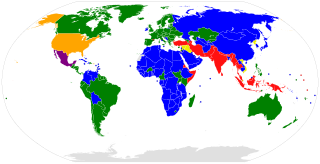
English: A map of the parties to the en:Geneva Conventions and Additional Protocols. Parties to GC I–IV and P I–III Parties to GC I–IV and P I–II Parties to GC I–IV and P I and III Parties to GC I–IV and P I Parties to GC I–IV and P III Parties to GC I–IV and no P |
| Data | (UTC) |
| Origem |
Este ficheiro foi derivado de: BlankMap-World6.svg: |
| Autor |
|
| Esta é uma imagem retocada, o que significa que a versão original foi alterada digitalmente. Modificações: coloured. O original pode ser visto aqui: BlankMap-World6.svg:
|
Licenciamento
Eu, titular dos direitos de autor desta obra, publico-a com a seguinte licença:
| Eu, titular dos direitos de autor desta obra, dedico-a ao domínio público, com aplicação em todo o mundo. Nalguns países isto pode não ser legalmente possível; se assim for: Concedo a todos o direito de usar esta obra para qualquer fim, sem quaisquer condições, a menos que tais condições sejam impostas por lei. |
Registo de carregamento original
This image is a derivative work of the following images:
- File:BlankMap-World6.svg licensed with PD-self
- 2013-06-05T18:47:10Z U+003F 863x443 (1619935 Bytes) Consolidated class definitions
- 2013-05-19T12:42:20Z U+003F 863x443 (1620274 Bytes) As below. The map seems not to have been replaced with the new version.
- 2013-05-18T20:25:36Z U+003F 863x443 (1621109 Bytes) Take 2. Added a element to name country, with the official name derived using existing 2-character [[w:ISO 3166-1 alpha-2|ISO 3166-1 alpha-2]] code. These country names will be displayed (in most browsers) when hovered over.
- 2013-05-18T20:21:34Z U+003F 863x443 (1621109 Bytes) Added a element to name country, with the official name derived using existing 2-character [w:ISO 3166-1 alpha-2|ISO 3166-1 alpha-2]] code. These country names will be displayed (in most browsers) when hovered over.
- 2012-12-11T10:09:32Z Konstantin Burov 863x443 (1654809 Bytes) Cleansed Inkscape tags so the file now passes W3G SVG validation, converted all relative coordinates into absolute so the file is parsable by the nugsl-worldmap script again. Fixed version of the script is available at [https
- 2012-11-30T16:49:28Z Yug 863x443 (1654809 Bytes) [[user:Konstantin_Burov]]'s fixes. I help her/him for this upload.
- 2012-10-30T00:27:03Z Chipmunkdavis 863x443 (1609186 Bytes) Reverted to version as of 13:37, 14 February 2012 POV pushing, neither Moroccos recognised borders, nor its de facto ones
- 2012-10-28T20:14:49Z Apolikamixitos 863x443 (1650219 Bytes) Fixing Morocco borders
- 2012-02-14T13:37:02Z Tentotwo 863x443 (1609186 Bytes) Removed hardcoded styles from sd, ss, and cf
- 2012-01-06T03:22:35Z Spesh531 863x443 (1651067 Bytes) Fixing South Sudan's border
- 2011-12-19T00:04:12Z Chipmunkdavis 863x443 (1612580 Bytes) Reverted to version as of 00:51, 27 August 2011
- 2011-12-18T15:14:45Z Anshulkumardhiman 1920x1080 (320804 Bytes) fixed background
- 2011-12-18T15:06:50Z Anshulkumardhiman 1920x1080 (323987 Bytes) fixed color texture
- 2011-08-27T00:51:14Z Anomie 863x443 (1612580 Bytes) South Sudan has been assigned code SS, so use that code.
- 2011-07-30T18:04:36Z Lokal Profil 863x443 (1612578 Bytes) Minor circle related changes and remove the legacy pentagram
- 2011-07-08T23:26:24Z NuclearVacuum 863x443 (1613386 Bytes) South Sudan is free!! Hooray
- 2011-07-04T20:41:30Z NuclearVacuum 863x443 (1615589 Bytes) Restored to previous version, as SS isn't independent yet. But the code is now ready and waiting
- 2011-07-04T20:40:06Z NuclearVacuum 863x443 (1613386 Bytes) Separated South Sudan from (North) Sudan in preparation for SS independence on July 9, 2011.
- 2011-06-27T15:15:14Z Canuckguy 863x443 (1615589 Bytes) restored PR, set id labels for West Bank and Gaza
- 2011-04-01T14:09:57Z NuclearVacuum 863x443 (1614917 Bytes) Mayotte is now a department of France
- 2011-02-17T14:31:36Z NuclearVacuum 863x443 (1614903 Bytes) minor fixes
- 2011-02-13T01:43:20Z Canuckguy 863x443 (1632654 Bytes) minor fix
- 2011-01-22T20:16:24Z NuclearVacuum 863x443 (1614900 Bytes) added lakes
- 2011-01-22T20:12:02Z NuclearVacuum 863x443 (1632622 Bytes) ...
- 2011-01-22T20:08:04Z NuclearVacuum 863x443 (1632651 Bytes) Reverted to version as of 18:31, 17 January 2011
- 2011-01-22T20:07:39Z NuclearVacuum 1173x937 (334238 Bytes) just testing something
- 2011-01-17T18:31:33Z NuclearVacuum 863x443 (1632651 Bytes) minor fix of Sudan
- 2011-01-17T18:26:18Z NuclearVacuum 863x443 (1632651 Bytes) minor fix
- 2011-01-17T18:17:24Z NuclearVacuum 863x443 (1632633 Bytes) clean code
- 2011-01-17T18:12:07Z NuclearVacuum 863x443 (1632625 Bytes) added new class of circles, added Southern Sudan as a region within Sudan.
- 2011-01-15T00:06:15Z NuclearVacuum 863x443 (1631574 Bytes) minor fix
- 2011-01-14T23:51:44Z NuclearVacuum 863x443 (1631571 Bytes) added missing regions of the European Union
- 2011-01-13T14:26:50Z NuclearVacuum 863x443 (1631559 Bytes) minor fix
- 2011-01-13T14:17:57Z NuclearVacuum 863x443 (1631550 Bytes) added the BES Islands to the Netherladns
- 2011-01-07T21:02:08Z NuclearVacuum 863x443 (1631333 Bytes) minor fix
- 2011-01-07T20:55:32Z NuclearVacuum 863x443 (1631333 Bytes) corrected code for the circles
- 2011-01-06T16:44:29Z NuclearVacuum 863x443 (1208206 Bytes) removed all but 5px of whitespace, see talk page
- 2011-01-03T14:03:40Z NuclearVacuum 854x433 (1208195 Bytes) Curaçao and Sint Maarten have been given codes
- 2011-01-02T03:21:03Z Tomchen1989 854x433 (1205379 Bytes) compromised for the bug
- 2010-12-28T01:58:24Z Kintetsubuffalo 853x433 (1205378 Bytes) what are you talking about? nothing is cut off or squished
- 2010-12-28T00:28:42Z NuclearVacuum 940x477 (1631321 Bytes) Reverted to version as of 16:43, 27 October 2010
- 2010-12-19T20:10:58Z Tomchen1989 853x433 (1205378 Bytes) stroke-width of coast
- 2010-12-19T08:51:57Z Tomchen1989 853x433 (1205378 Bytes) minor change
- 2010-12-16T16:14:47Z Tomchen1989 853x433 (1205378 Bytes) radius of the circles changed
- 2010-12-14T22:57:20Z Tomchen1989 853x433 (1208461 Bytes) small fixed
- 2010-12-14T22:36:00Z Tomchen1989 853x433 (1208830 Bytes) had outside whitespace removed; cleaned the code; used tab indent
- 2010-10-27T16:43:23Z NuclearVacuum 940x477 (1631321 Bytes) fixed as part of discussion
- 2010-10-24T03:54:05Z NuclearVacuum 940x477 (1630960 Bytes) I fixed the code so it is valid
- 2010-10-10T22:06:16Z Canuckguy 940x477 (1630991 Bytes) Reverted to version as of 02:01, 18 September 2010 (Neth. Antilles removed, Sint Maarten and Curacao added, Bonaire part of "nl")
- 2010-09-18T02:01:50Z Canuckguy 940x477 (1630802 Bytes) Reverted to version as of 01:03, 9 July 2010. New version to be used October 10, 2010
Carregada com derivativeFX
Histórico do ficheiro
Clique uma data e hora para ver o ficheiro tal como ele se encontrava nessa altura.
| Data e hora | Miniatura | Dimensões | Utilizador | Comentário | |
|---|---|---|---|---|---|
| atual | 03h51min de 18 de janeiro de 2022 | | 863 × 443 (1,58 MB) | Danlaycock | update cm |
| 15h52min de 16 de janeiro de 2021 |  | 863 × 443 (1,58 MB) | Danlaycock | update ec | |
| 14h39min de 4 de julho de 2020 |  | 863 × 443 (1,58 MB) | Danlaycock | cleanup markup | |
| 23h48min de 1 de julho de 2020 |  | 863 × 443 (1,58 MB) | TheNavigatrr | Unlike British Overseas Territories and the UK, all U.S. territories are part of the United States. Coloring Puerto Rico, U.S. Virgin Islands, Northern Mariana Islands, and Guam (all of which are either territories with Commonwealth status or organized territories). | |
| 23h01min de 1 de julho de 2020 |  | 863 × 443 (1,58 MB) | TheNavigatrr | Angola is a party to Protocol II. They acceded to it on 10 July 2019: https://ihl-databases.icrc.org/applic/ihl/ihl.nsf/States.xsp?xp_viewStates=XPages_NORMStatesParties&xp_treatySelected=475 | |
| 16h48min de 26 de abril de 2020 |  | 863 × 443 (1,58 MB) | Danlaycock | update Lesotho | |
| 00h45min de 23 de maio de 2019 |  | 863 × 443 (1,58 MB) | Danlaycock | update .kg | |
| 02h05min de 20 de dezembro de 2018 |  | 863 × 443 (1,58 MB) | Danlaycock | update .pe | |
| 00h40min de 14 de agosto de 2018 |  | 863 × 443 (1,58 MB) | Danlaycock | +mg | |
| 16h51min de 11 de junho de 2017 |  | 863 × 443 (1,58 MB) | Danlaycock | update .bf |
Utilização local do ficheiro
A seguinte página usa este ficheiro:
Utilização global do ficheiro
As seguintes wikis usam este ficheiro:
- az.wikipedia.org
- cs.wikipedia.org
- de.wikipedia.org
- en.wikipedia.org
- es.wikipedia.org
- fa.wikipedia.org
- hy.wikipedia.org
- id.wikipedia.org
- it.wikipedia.org
- ja.wikipedia.org
- ko.wikipedia.org
- mk.wikipedia.org
- ru.wikipedia.org
- sr.wikipedia.org
- sv.wikipedia.org
- th.wikipedia.org
- tr.wikipedia.org
- uk.wikipedia.org
- zh.wikipedia.org