
Ficheiro:Provinces of France.png
Imagem numa resolução maior (894 × 899 píxeis, tamanho: 39 kB, tipo MIME: image/png)
|
|
Esta imagem provém do Wikimedia Commons, um acervo de conteúdo livre da Wikimedia Foundation que pode ser utilizado por outros projetos.
|

|
File:Provinces of France (numered-monochrome).svg é uma versão vetorial deste ficheiro. Ela deve ser usada em vez desta imagem em formato raster, se não for de qualidade inferior.
File:Provinces of France.png → File:Provinces of France (numered-monochrome).svg
Para mais informações, consulte Ajuda:SVG. |
.svg) |
Descrição do ficheiro
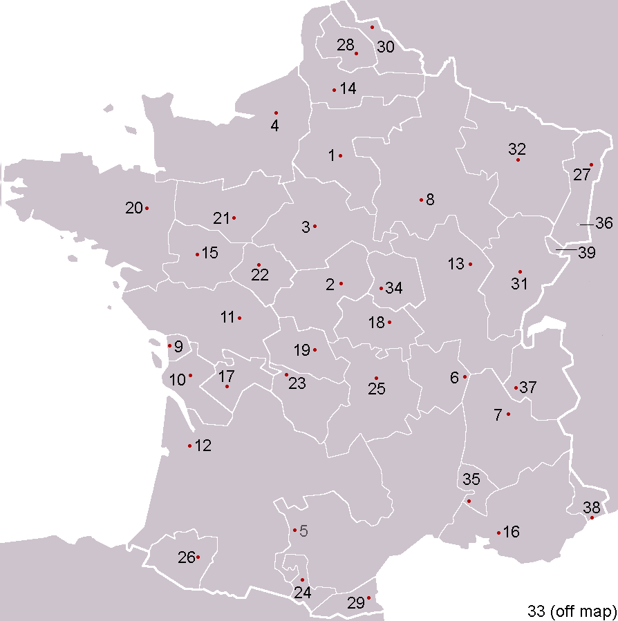
Pre-Republican provinces of France, numbered according to union with France, with provincial capitals marked.
Created by reference to a 1952 Nouveau Petit Larousse by User:OwenBlacker and licenced under the GFDL.
Provinces as follows, in the format English name (French name, Year of union; Capital):
- Royal Domain (Île-de-France, 987, Paris)
- Berry (Berry, 1101, Bourges)
- Duchy of Orléanais (Orléanais, 1198, Orléans)
- Normandy (Normandie, 1204, Rouen)
- Languedoc, mainly the County of Toulouse (Languedoc, 1270, Toulouse)
- Lyonnais (Lyonnais, 1313, Lyon)
- Dauphiné, (Dauphiné, 1349, Grenoble)
- County of Champagne (Champagne, 1361, Troyes)
- Aunis, a fief of Aquitaine (Aunis, 1371, La Rochelle)
- Saintonge (Saintonge, 1371, Saintes)
- Poitou (Poitou, 1416, Poitiers)
- Duchy of Aquitaine (Aquitaine, 1453, Bordeaux), taken from England and split into provinces of Gascogne (Armagnac) and Guyenne (Bordeaux), but excluding the viscounties of Foix, Béarn, Bigorre and Périgord (kept by Navarre)
- Duchy of Burgundy (Bourgogne, 1477, Dijon)
- Picardy (Picardie, 1482, Amiens)
- Anjou (Anjou, 1482, Angers)
- County of Provence (Provence, 1482, Aix-en-Provence)
- County of Angoulême (Angoumois, 1515, Angoulême)
- Duchy of Bourbon (Bourbonnais, 1527, Moulins)
- La Marche (Marche, 1527, Guéret)
- Duchy of Britanny (Bretagne, 1532, Rennes)
- County of Maine (Maine, 1584, Le Mans) and County of Perche (Perche, 1525, Nogent-le-Rotrou)
- Touraine (Touraine, 1584, Tours)
- Limousin (Limousin, 1589, Limoges), excluding Viscounty of Périgord (kept by Navarre)
- County of Foix (Comté de Foix, 1607, Foix) and Viscounty of Périgord (Périgord, 1607, Périgueux, attached to province of Guyenne), both former fiefs from Navarre
- Duchy of Auvergne (Auvergne, 1610, Clermont-Ferrand)
- Viscounty of Béarn (Béarn, 1620, Pau)
- Alsace (Alsace, 1648, Strasbourg)
- County of Artois, a fief of the w:Habsburgs' Spanish Netherlands (Artois, 1659, Arras)
- Roussillon (Roussillon, 1659, Perpignan)
- Flanders, a fief of the w:Habsburgs' Spanish Netherlands (Flandre, 1668, Lille)
- Free County of Burgundy (Franche-Comté, 1678, Besançon)
- Duchy of Lorraine, a personal territory of Stanisław I of Poland within the Holy Roman Empire (Lorraine, 1766, Nancy)
- Corsica (off map, Corse, 1768, Ajaccio)
The following were not provinces of France before the Revolution, but joined or were annexed to France after it, when departments had replaced all former provinces: - Duchy of Nivernais (Nivernais, 1789, Nevers)
- Comtat Venaissin, a Papal fief (Comtat Venaissain, 1791, Avignon)
- Imperial Free City of Mulhouse (Mulhouse, 1798)
- Duchy of Savoy, a state of the Kingdom of Sardinia-Piedmont (Savoie, 1860, Chambéry)
- County of Nice, a state of the Kingdom of Sardinia-Piedmont (Comté de Nice, 1860, Nice)
- Principality of Montbéliard (Montbéliard, 1816, Montbéliard)
- Free cities of Menton and Roquebrune (1861), joining France after the separation (under the protectorate of Sardinia) in 1848 from Monaco

|
É concedida permissão para copiar, distribuir e/ou modificar este documento nos termos da Licença de Documentação Livre GNU, versão 1.2 ou qualquer versão posterior publicada pela Free Software Foundation; sem Secções Invariantes, sem textos de Capa e sem textos de Contra-Capa. É incluída uma cópia da licença na secção intitulada GNU Free Documentation License. |
| A utilização deste ficheiro é regulada nos termos da licença Creative Commons - Atribuição-CompartilhaIgual 3.0 Não Adaptada. | ||
| ||
| Esta marca de licenciamento foi adicionada a este ficheiro durante a atualização da licença GFDL. |
derivative works
Obras derivadas deste ficheiro: Forteresses marches de Bretagne.png
Histórico do ficheiro
Clique uma data e hora para ver o ficheiro tal como ele se encontrava nessa altura.
| Data e hora | Miniatura | Dimensões | Utilizador | Comentário | |
|---|---|---|---|---|---|
| atual | 00h53min de 5 de fevereiro de 2005 | | 894 × 899 (39 kB) | OwenBlacker | Corrected map |
| 23h59min de 4 de fevereiro de 2005 |  | 894 × 899 (39 kB) | OwenBlacker | Corrected map | |
| 20h24min de 4 de fevereiro de 2005 |  | 894 × 899 (39 kB) | OwenBlacker | Pre-Republican provinces of France |
Utilização local do ficheiro
As seguintes 35 páginas usam este ficheiro:
- Alsácia
- Anjou
- Antigas províncias da França
- Aunis
- Auvérnia
- Bearne
- Berry (província)
- Borbonês
- Borgonha
- Bretanha
- Champanhe (província)
- Condado da Marcha
- Condado de Foix
- Córsega
- Delfinado
- Flandres (província)
- Franco-Condado
- Gasconha
- Guiena
- Ilha de França
- Languedoc
- Limusino (província)
- Lionês
- Lorena
- Maine (província)
- Normandia
- Orleanês
- Picardia
- Poitou
- Provença
- Quercy
- Rossilhão
- Saboia
- Turene
- Predefinição:Antigas províncias da França
Utilização global do ficheiro
As seguintes wikis usam este ficheiro:
- an.wikipedia.org
- ar.wikipedia.org
- كورسيكا
- لورين (منطقة)
- لانغيدوك
- بروفنس
- غشكونية
- بيكاردي
- ألزس
- إيل دو فرانس
- ليموزان
- أوني
- إفرنش كمته
- منطقة سافوا
- دوفيني
- روسيون (مقاطعة)
- قالب:مقاطعات فرنسية سابقة
- بيرش
- برطانية (فرنسا)
- أنجو
- بواتو
- مين (مقاطعة)
- بونيفاسيو
- شامبانيا (مقاطعة)
- دوقية نرمندية
- دول (فرنسا)
- بروفين
- تيل (فرنسا)
- آجدي
- روآن
- فوجير
- مورلي (فرنسا)
- بوتو (فرنسا)
- آركاشون
- جينيفيلييه
- بريانسون
- كاستيلان
- بيساك
- بنطيز
- أوري (فرنسا)
- كاربينتراس
- درو (فرنسا)
- ألتكيرش
- آنجليه
- أرجينتان
- أوبيناس
- إبلافية
- بريودي
- كابورج
- قشتال
- فورباخ
Ver mais utilizações globais deste ficheiro.