
Ficheiro:Achaemenid empire map expansion.png
Dimensões desta antevisão: 800 × 511 píxeis. Outras resoluções: 320 × 205 píxeis | 640 × 409 píxeis | 1 020 × 652 píxeis.
Imagem numa resolução maior (1 020 × 652 píxeis, tamanho: 34 kB, tipo MIME: image/png)
|
|
Esta imagem provém do Wikimedia Commons, um acervo de conteúdo livre da Wikimedia Foundation que pode ser utilizado por outros projetos.
|
Descrição do ficheiro
| Descrição |
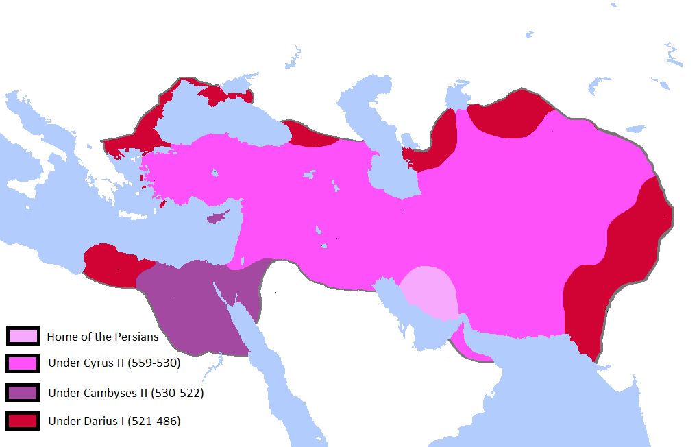
English: Updated the map by delineating the conquests of the three major Persian conqueror Kings, and also adding the names of the main satrapies of the empire. As a source I used this map of Ian Mladjov's Resources from the University of Michigan's History department. Link:http://sitemaker.umich.edu/mladjov/home |
| Data | |
| Origem | On Microsoft Paint |
| Autor | Javierfv1212 |
Licenciamento
Eu, titular dos direitos de autor desta obra, publico-a com as seguintes licenças:

|
É concedida permissão para copiar, distribuir e/ou modificar este documento nos termos da Licença de Documentação Livre GNU, versão 1.2 ou qualquer versão posterior publicada pela Free Software Foundation; sem Secções Invariantes, sem textos de Capa e sem textos de Contra-Capa. É incluída uma cópia da licença na secção intitulada GNU Free Documentation License. |
A utilização deste ficheiro é regulada nos termos da licença Creative Commons - Atribuição-CompartilhaIgual 3.0 Não Adaptada.
- Pode:
- partilhar – copiar, distribuir e transmitir a obra
- recombinar – criar obras derivadas
- De acordo com as seguintes condições:
- atribuição – Tem de fazer a devida atribuição da autoria, fornecer uma hiperligação para a licença e indicar se foram feitas alterações. Pode fazê-lo de qualquer forma razoável, mas não de forma a sugerir que o licenciador o apoia ou subscreve o seu uso da obra.
- partilha nos termos da mesma licença – Se remisturar, transformar ou ampliar o conteúdo, tem de distribuir as suas contribuições com a mesma licença ou uma licença compatível com a original.
Pode escolher a licença que quiser.
Histórico do ficheiro
Clique uma data e hora para ver o ficheiro tal como ele se encontrava nessa altura.
| Data e hora | Miniatura | Dimensões | Utilizador | Comentário | |
|---|---|---|---|---|---|
| atual | 00h41min de 14 de outubro de 2015 | | 1 020 × 652 (34 kB) | LouisAragon | Reverted mostly hoax edits (except Macedon) by user:HistoryofPersia |
| 23h40min de 11 de outubro de 2015 |  | 1 012 × 648 (34 kB) | History of Persia | macedonia | |
| 17h29min de 3 de agosto de 2015 |  | 1 012 × 648 (32 kB) | History of Persia | There is no account saying cambyses conquered cyprus (the island), so it is more likely that it was conquered by cyrus, and became part of the babylonian province (which became the eber-nari province | |
| 16h51min de 3 de agosto de 2015 |  | 1 012 × 648 (32 kB) | History of Persia | Cambyses did not subdue the arabs in his egyptian campaign. achaemenid arabia only appears in an inscription from the reign of darius. But it is possible that (along with eber nari), arabia was originally part of the babylonian province but later split... | |
| 00h08min de 2 de agosto de 2015 |  | 1 012 × 648 (32 kB) | History of Persia | Gandhara empires borders where more like this version of the file. evidence: http://www.worldhistorymaps.info/images/East-Hem_600bc.jpg & https://en.wikipedia.org/wiki/Gandhara_Kingdom#/media/File:Gandhara.JPG. no one noticed until now i guess | |
| 23h45min de 1 de agosto de 2015 |  | 1 020 × 652 (34 kB) | History of Persia | Added territories of the gandhara kingdom and a more likely border of gedrosia | |
| 16h13min de 27 de julho de 2015 |  | 1 020 × 652 (34 kB) | History of Persia | Cyrus created cyropolis | |
| 06h59min de 16 de julho de 2015 |  | 1 020 × 652 (34 kB) | History of Persia | if readers want to see the provinces/satrapies they can see another map. For the map of the empire we dont need the inclusion of satrapies. | |
| 23h42min de 26 de fevereiro de 2015 |  | 1 020 × 652 (59 kB) | Javierfv1212 | {{subst:Upload marker added by en.wp UW}} {{Information |Description = {{en|Updated the map by delineating the conquests of the three major Persian conqueror Kings, and also adding the names of the main satrapies of the empire. As a source I used this... |
Utilização local do ficheiro
As seguintes 4 páginas usam este ficheiro:
Utilização global do ficheiro
As seguintes wikis usam este ficheiro:
- ar.wikipedia.org
- en.wikipedia.org
- hy.wikipedia.org
- hyw.wikipedia.org
- ku.wikipedia.org
- tr.wikipedia.org