
Ficheiro:Tübingen - Altstadt - Neckarfront - Ansicht von Neckarinsel mit Stocherkahn.jpg

Dimensões desta antevisão: 800 × 527 píxeis. Outras resoluções: 320 × 211 píxeis | 640 × 421 píxeis | 1 024 × 674 píxeis | 1 280 × 842 píxeis | 2 560 × 1 685 píxeis | 7 287 × 4 796 píxeis.
Imagem numa resolução maior (7 287 × 4 796 píxeis, tamanho: 31,52 MB, tipo MIME: image/jpeg)
|
|
Esta imagem provém do Wikimedia Commons, um acervo de conteúdo livre da Wikimedia Foundation que pode ser utilizado por outros projetos.
|
Descrição do ficheiro
| Descrição |
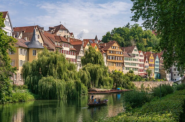
Deutsch: Tübingen: Mit das bekannteste historische Gebäude-Ensemble der Altstadt dürfte die so genannte Neckarfront sein, die fast vollständig aus denkmalgeschützten Gebäuden besteht. Hier eine Ansicht aus Süd-Südwesten von der Neckarinsel über den Neckar, passenderweise mit einem typischen Tübinger Stocherkahn. Links der Hölderlinturm hinter seiner prächtigen Trauerweide, rechts davon die Reihe der historischen Bürgerhäuser.
English: Tübingen, Germany: Probably the best known ensemble of historic buildings in Tübingen is the so-called Neckarfront, which consists almost entirely of listed buildings. It is mostly photographed from the Neckar bridge, therefore with this photo I have tried to show a less known view from the island in the river Neckar. In the middle on the river Neckar there is a Stocherkahn (punt) passing, very typical for Tübingen. On the left you see the Hölderlinturm behind its magnificent weeping willow, on the right the row of historic town houses.
Polski: Tybinga, Niemcy: Jeden z najsłynniejszych zespołów budynków staromiejskich, tzw. Neckarfront, składający się prawie w całości z zabytkowych kamienic. Widok z południowo-zachodniej części wyspy platanów Plataneninsel, wraz z typową łódką płynącą po rzece Neckar. Po lewej, skryta za okazałą wierzbą płaczącą, wieża Hölderlina, w której spędził 5 ostatnich lat życia.
Українська: Тюбінген, Німеччина: Напевно, найвідоміший ансамбль історичних будівель у Тюбінгені - це так званий «Некарфронт», який майже повністю складається із перелічених будівель. Здебільшого фотографовав з мосту Некар, тому на цій фотографії я спробував показати менш відомий вид з "Платанінінселя" (острова платанів). Посередині на річці Некар знаходиться прохід для човнів Stocherkahn, що є типовим для Тюбінгена. Зліва ви бачите Hölderlinturm за його чудовою плакучою вербою, праворуч ряд історичних міських будинків.
Čeština: Skupina historických domů s názvem Neckarfront v německém městě Tübingen na nábřeží řeky Neckar.
Español: Vista de un conjunto de edificios históricos a orillas del río Neckar en el casco antiguo de Tubinga desde el suroeste de la isla de los plátanos. A la izquierda, la torre Hölderlin detrás de un sauce llorón, frente a ella, en el Neckar, navega una embarcación típica de Tubinga, el Stocherkahn.
Magyar: Tübingen; Az óváros leghíresebb történelmi épületegyüttese, az úgynevezett Neckarfront a Platán-sziget délnyugati részéről. Bal oldalon a Hölderlin-torony a szomorúfűz mögött, előtte a Neckaron tipikusan Tübingenre jellemző csónak (Németország)
한국어: 일명 네카르프론트라 불리는 이곳은 독일 튀빙겐의 관광 명소이다. 대부분의 건물이 문화재로 등록되어 있다. 이 사진은 네카르강의 작은 섬에서 찍은 것이다. 강에는 작은 배가 떠가는데, 튀빙겐에서는 흔한 풍경이다. 사진 왼쪽에는 아름다운 수양버들 뒤로 시인 프리드리히 횔덜린이 살았던 횔덜린 탑이 보인다.
Эрзянь: Тюбинген, Германия: ашти лемдязь Неккарфронт (Neckarfront) таркасонть. Фотось теезь Платаненинзелю» (платанонь усият) (Plataneninsel). Куншка таркасо, Неккар лейсэнть ашти Стохеркан Stocherkahn (платанонь усият) таркась, кона Тюбингенсэ сеетьстэ вастневи. Керш ёндо неят Hölderlinturm кона кекшеви кальчувтнэсэ.
Nederlands: Vrijwel al deze gebouwen langs de oever van de Neckar in Tübingen in Baden-Württemberg vallen onder de Duitse monumentenzorg
Português: Panorama de um conjunto de edifícios históricos às margens do rio Neckar no bairro antigo de Tübingen, Alemanha, visto do sudoeste da ilha dos plátanos. À esquerda, a torre Hölderlin atrás de um salgueiro-chorão, em frente a ela, no Neckar, navega uma embarcação típica de Tübingen, o Stocherkahn |
| Data | Tirada em 6 de agosto de 2019, 11:39:40 |
| Origem | Obra do próprio |
| Autor | Roman Eisele |
| Localização da câmara | | Esta e outras imagens nas suas localizações em: OpenStreetMap |
|---|
| Espaço de cor | This image file uses the sRGB colour space. (Fortunately today most systems and applications respect colour spaces and ICC profiles. But there may still be some exceptions: outdated or misconfigured software can display wrong colours. If you see strange colours or if the picture appears flat and low in contrast, you should try another application or device for viewing it.) |
| Personal photo ID | RQBA7935 (This is the reference number of this photograph in my archive. Please do not delete it, it is very useful for me! You may use this ID if you need to refer to one of my photographs.) |
| Atribuição (requerido pela licença) | © Roman Eisele / CC BY-SA 4.0 |
| Using this picture | You can use this picture free of charge under the terms of the free license CC BY-SA 4.0. In particular, this means:
|
| Editing this picture | If you want to edit this picture for Commons, please upload your edited version using a new file name. My own version of this picture should be preserved and must be easily accessible. Please add the template {{Derived from}} or {{Extracted from}} to your version and use it to link to my original version of the picture. Thank you very much! |

|
Esta imagem foi carregada como parte do Wiki Loves Monuments 2019.
|
Avaliação
|

Esta imagem foi escolhida como imagem do dia na wiki Wikimedia Commons para 5 de agosto de 2020. Teve a seguinte legenda: Português: Panorama de um conjunto de edifícios históricos às margens do rio Neckar no bairro antigo de Tübingen, Alemanha, visto do sudoeste da ilha dos plátanos. À esquerda, a torre Hölderlin atrás de um salgueiro-chorão, em frente a ela, no Neckar, navega uma embarcação típica de Tübingen, o Stocherkahn Outros idiomas:
Čeština: Skupina historických domů s názvem Neckarfront v německém městě Tübingen na nábřeží řeky Neckar. Deutsch: Tübingen: Ansicht des wohl bekanntesten historischen Gebäude-Ensembles der Altstadt, der so genannten Neckarfront, aus Südwesten von der Plataneninsel. Links der Hölderlinturm hinter seiner prächtigen Trauerweide, davor auf dem Neckar der für Tübingen so typische Stocherkahn. English: Tübingen, Germany: The so-called Neckarfront consists almost entirely of listed buildings. This photo shows it as seen from the Plataneninsel (plane tree island). In the middle on the river Neckar there is a Stocherkahn (punt) passing, very typical for Tübingen. On the left you see the Hölderlinturm behind its magnificent weeping willow. Español: Vista de un conjunto de edificios históricos a orillas del río Neckar en el casco antiguo de Tubinga desde el suroeste de la isla de los plátanos. A la izquierda, la torre Hölderlin detrás de un sauce llorón, frente a ella, en el Neckar, navega una embarcación típica de Tubinga, el Stocherkahn. Magyar: Tübingen; Az óváros leghíresebb történelmi épületegyüttese, az úgynevezett Neckarfront a Platán-sziget délnyugati részéről. Bal oldalon a Hölderlin-torony a szomorúfűz mögött, előtte a Neckaron tipikusan Tübingenre jellemző csónak (Németország) Nederlands: Vrijwel al deze gebouwen langs de oever van de Neckar in Tübingen in Baden-Württemberg vallen onder de Duitse monumentenzorg Português: Panorama de um conjunto de edifícios históricos às margens do rio Neckar no bairro antigo de Tübingen, Alemanha, visto do sudoeste da ilha dos plátanos. À esquerda, a torre Hölderlin atrás de um salgueiro-chorão, em frente a ela, no Neckar, navega uma embarcação típica de Tübingen, o Stocherkahn |
Licenciamento
Eu, titular dos direitos de autor desta obra, publico-a com a seguinte licença:
A utilização deste ficheiro é regulada nos termos da licença Creative Commons Atribuição-CompartilhaIgual 4.0 Internacional.
- Pode:
- partilhar – copiar, distribuir e transmitir a obra
- recombinar – criar obras derivadas
- De acordo com as seguintes condições:
- atribuição – Tem de fazer a devida atribuição da autoria, fornecer uma hiperligação para a licença e indicar se foram feitas alterações. Pode fazê-lo de qualquer forma razoável, mas não de forma a sugerir que o licenciador o apoia ou subscreve o seu uso da obra.
- partilha nos termos da mesma licença – Se remisturar, transformar ou ampliar o conteúdo, tem de distribuir as suas contribuições com a mesma licença ou uma licença compatível com a original.
Histórico do ficheiro
Clique uma data e hora para ver o ficheiro tal como ele se encontrava nessa altura.
| Data e hora | Miniatura | Dimensões | Utilizador | Comentário | |
|---|---|---|---|---|---|
| atual | 10h06min de 3 de novembro de 2019 | | 7 287 × 4 796 (31,52 MB) | Aristeas | Cropped version without masking, according to the suggestions in the FPC discussion and on COM:IDENT |
| 12h54min de 29 de setembro de 2019 |  | 7 287 × 4 796 (31,53 MB) | Aristeas | Cropped version | |
| 12h49min de 29 de setembro de 2019 |  | 7 596 × 5 189 (34,84 MB) | Aristeas | User created page with UploadWizard |
Utilização local do ficheiro
As seguintes 2 páginas usam este ficheiro:
Utilização global do ficheiro
As seguintes wikis usam este ficheiro:
- be-tarask.wikipedia.org
- bn.wikipedia.org
- crh.wikipedia.org
- cs.wikipedia.org
- cv.wikipedia.org
- de.wikipedia.org
- Benutzer:Aristeas
- Platanenallee (Tübingen)
- Neckarfront
- Wikipedia:Wiki Loves Monuments 2019/Deutschland/Vorjury/Ergebnis
- Wikipedia:Wiki Loves Monuments 2019/Deutschland/Preisträger
- Wikipedia:Wiki Loves Monuments 2020/Deutschland/Rückblick
- Wikipedia:Wiki Loves Monuments 2021/Deutschland/Rückblick
- Wikipedia:Wiki Loves Monuments 2022/Deutschland/Rückblick
- Wikipedia:Wiki Loves Monuments 2023/Deutschland/Preise
- Wikipedia:Wiki Loves Monuments 2024/Deutschland/Preise
- de.wikivoyage.org
- en.wikipedia.org
- et.wikipedia.org
- fa.wikipedia.org
- fr.wikipedia.org
- he.wikipedia.org
- טיבינגן
- פורטל:גרמניה/תמונה נבחרת/גלריה2
- משתמש:Tomer T/תמונות שהצעתי
- ויקיפדיה:תמונה מומלצת/המלצות קודמות/מרץ 2020
- ויקיפדיה:תמונה מומלצת/הוספה למומלצים/ארכיון 126
- תבנית:תמונה מומלצת 24 במרץ 2020
- ויקיפדיה:תמונה מומלצת/המלצות קודמות/מרץ 2021
- תבנית:תמונה מומלצת 24 במרץ 2021
- ויקיפדיה:תמונה מומלצת/המלצות קודמות/מרץ 2022
- תבנית:תמונה מומלצת 22 במרץ 2022
- פורטל:גרמניה/תמונה נבחרת/79
- hu.wikipedia.org
- hy.wikipedia.org
- id.wikipedia.org
- Wikipedia:Gambar pilihan/Usulan/2020
- Wikipedia:Gambar pilihan/Usulan/2020/Periode 22
- Wikipedia:Gambar pilihan/Usulan/2022
- Wikipedia:Gambar pilihan/Usulan/2022/Periode 11
- Wikipedia:Gambar pilihan/2022
- Wikipedia:Gambar pilihan/43 2022
- Wikipedia:Arsip halaman utama/2022/06/18
- Wikipedia:Arsip halaman utama/2022/06/19
Ver mais utilizações globais deste ficheiro.